The City of Toronto publishes a number of free maps - especially to show various scenic walking routes throughout the city. The smaller maps are called "Discovery Walks" and one of them depicts the walking trail along Burke Creek.
The walk begins at a middle school in the upper middle class suburb of Forest Hill. It was a lovely warm autumn day when I decided to explore this route. I rode the subway north up Yonge Street to the Lawrence Subway Station and then walked the three blocks south to the street that gave me best access to the trail head.
In order to reach the trail I had to walk along the school's driveway and through the staff parking lot to where the 'Discovery Walk' commenced. Three girls of middle school age were sitting in the sunshine on the school lawn and one of them called out to me, "Are you an explorer?" I said, "Yes!" with a grin. The same girl called back, "Can we have your autograph then?" I laughed and walked on.
Where the trail began at the edge of the school grounds.
The trail took me back down to Yonge Street and, just before I exited the woods in order to cross that street I noticed a tree with a large fungus growing just beneath the lowest bough. This is a common sight in the rain forests on the West Coast but the first one that I had seen in and around Toronto.
On the east side of Yonge at that point are the Muir Gardens.
Above is the plaque dedicating the park to the memory of Alexander Muir and that photo is followed by one of the gardens.
Lower Muir Gardens
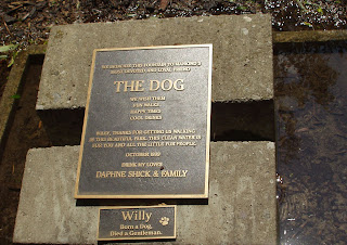
A family, who lived in that area, had this monument erected in memory of a beloved pet.
The monument is a fountain so placed that passing dogs can drink from it.
Just before the hiking trail left the landscaped park area and re-entered the forest I noticed this unusual stump.
The trail beckoned me to continue the walk.
I never understand pranksters - why would someone - or people - pick up a picnic table and dump it into a stream? (Following photo)
Not far away I came upon a butterfly sitting on the pathway with its wings folded.
A cluster of daisies growing beside the path.
A little further along I entered the areas named 'Blythewood' and 'Sherwood Forest' where the path became an elevated boardwalk.
Arriving where Bayview Avenue - a major north/south thoroughfare - bisected the walking path I ended the walk for that day - but continued on the following day. With Toronto's excellent transit system, one is seldom far from a bus or subway route. There is frequent bus service along Bayview Avenue - connecting with the subway at the Lawrence Subway Station - so it was easy to leave and to return on the following afternoon.
However, as I neared the roadway, there were a couple more nice scenes.
Sunlight dappling on leaves.
Some wild flowers.
Returning to the walk on the following day meant some scrambling on my part to pick up the trail - the connection to and from the higher roadway had not been completed.
I descended the steep bank and found myself where Burke Creek flowed into the West Don River in Sunnybrook Park which is a part of the larger Don River Valley park system. The northern part of Sunnybrook Park consists of large sports playing fields and, to the south of that (where the path that I was following ended) there are two stables.
One is where the Toronto Police Mounted Division stable their horses and, next to it, is a public riding stable and the place where city residents can stable their ponies.
Some of the police horses and in this next photo.
And right next door is the public riding stable.
My route back home extended for a few more miles of hiking and I will cover that in the next blog.


No comments:
Post a Comment